


Launching at Coal Banks Landing
Posted July 6, 2011
 Yes, launching, not lunching, at Coal Banks. My belly is still full from breakfast at the Virgelle Merc.
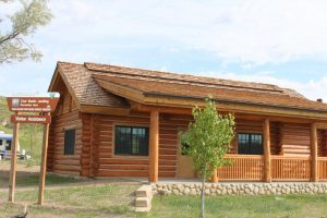
The first thing I notice when I drive one mile from the Merc to the landing is the new BLM building. There are campground hosts here and in years past they have hung out in or near their camp trailer. Now, they have an actual building, small and spartan, but it looks to be just what they can use for their volunteer shift here.
You don’t need a permit to be on the Upper Missouri River but for safety’s sake and the sake of managing this spectacular river corridor, voluntary registration is requested. The campground hosts greet us, record the number in our group and note how far we plan to go.
It’s a beautiful morning, puffy clouds, just-rite temp, blue sky, and our river guide for the day is ready for our group.
Bill Marsik, Missouri Breaks River Co., does motorized trips on the Upper Missouri River. I suspect most of his clients do the same trip we have planned for today – going downstream through the White Cliffs of the Missouri. We are launching at Coal Banks Landing (mile marker 41.5) and taking out at Judith Landing (mile marker 88.5). A quick study of the math and I determine we’ll travel 47 miles on the river today.
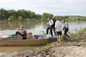 Everyone always seems a little antsy when it’s time to launch. Did I bring enough stuff? Did I remember everything? Did I drink too much coffee?
Bill soon put us at ease and we all picked out life jackets and found our positions in the jetboat. Our history lesson(s) started right away. I think we all felt a bit like Lewis & Clark did as they traveled this river. We launched just downstream from where the Lewis & Clark expedition camped June 1, 1805. OK, we were going downstream in a motorized boat, they poled and tugged upstream but you get the idea. Immersion in history is fairly easy for me, particularly when I’m comfy. Bill knew the Lewis & Clark history that took place on this river and he knew geology of the area. We were fascinated with his knowledge.
For our first few miles we traveled about 8 miles per hour. There are no-wake restrictions on the portion of the Missouri we were nearing and also restrictions about upstream travel. Our speed slowed when we reached a certain area and then we pretty much idled along.
Our first stop was at Eagle Creek campground. The BLM manages the Wild & Scenic Missouri, also the Upper Missouri River Breaks National Monumument surrounding the river and they maintain the designated camp sites. We had gone about 15 miles downstream.
Bill maneuvered the jetboat to a safe landing by the campground and he was the only one who actually got muddy. The river had receded a few inches a couple of days ago so the edges were muddy. He tugged the boat closer in for us (just to get that Lewis & Clark experience) and we stepped out of the boat and on to vegetation.
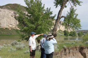 Here’s another classic Lewis & Clark portrayal – for now I will call it the Meriwether Lewis’ “we proceeded on” point. Bill was talking and pointing towards the site of the May 31, 1806 Lewis & Clark campsite and I caught the pose on camera!
All kidding aside, we were soaking up this over-200 year old history in a largely unchanged setting. Pretty amazing when you think of all the changes that could have happened here in the last 200 years.
To say the least, we were mesmerized. Stay tuned, I have many photos of the noted White Cliffs of the Missouri.
Recent Posts
September 15, 2023
I’ve always felt it is hard to put into words how special Autumn in Central Montana can feel. Ther air…
Read More
July 7, 2023
If you’re looking for a place to expand your horizons, literally and figuratively, then Central Montana needs to be at…
Read More
May 30, 2023
Silence the noise, escape the hurry, and feel light years away in the dark skies of Central Montana – where…
Read More