


Highlights of the Hi-Line in Central Montana
Posted February 24, 2021

Veteran’s Memorial overlooking Shelby
We’ve heard it called quirky, iconic, historic, scenic, and a step back in time. Those monikers all describe US Hwy 2 as it stretches across Montana for about 650 miles. Locals call it Montana’s Hi-Line since it’s the northernmost route traversing the state from east to west. We call it an interesting and fun drive.
Let’s talk about some of the gems along US Hwy 2 in Central Montana.
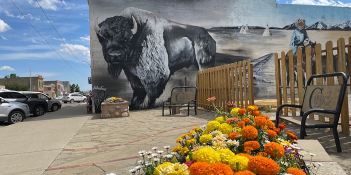
On our western edge, travelers are near the entrance to Glacier National Park. Magnificent views, jutting mountain peaks and the Going to the Sun road that bisects the park, are true wonders. As you leave the Rocky Mountains heading east and entering the plains, the highway follows close to the rail line for Amtrak. Highway 2 travels right through Shelby, a community of about 3,000 people, where you’ll find unique local shops, a carousel (kids and adults love it), the Marias Valley Golf Course, and the Marias Museum. A glance back in history brings up Shelby’s historic Dempsey-Gibbons heavyweight title boxing match July 4, 1923. The museum has the largest collection of memorabilia from the fight including one pair of gloves used, along with plenty of area history.

Scenic view along the south side of the Sweet Grass Hills
North of Highway 2 are several prominent peaks that definitely stand out on this rolling plain. The Sweet Grass Hills are isolated volcanic peaks that can be seen for miles, each with sacred and spiritual meaning to area Native American tribes. Several gravel roads off the highway take you close to the hills that have elevations of nearly 7,000 feet. Grain fields, grazing cattle, remnants of old homesteads, a small church and a scenic view around each curve all add to this beautiful and unique landscape.

Pugsley bridge over the Marias River
East of Shelby, about 44 miles, is the town of Chester. As you cruise along the highway between Shelby and Chester you don’t see Lake Elwell and Tiber Reservoir, but you aren’t far from them. Tiber Dam impounds the Marias River, originally constructed for irrigation, but it’s now a mecca for recreation – boating, fishing, water skiing, camping, picnicking and bird watching. The lake has 181 miles of shoreline with several gravel roads off Highway 2 for lake access. Interpretive panels near the lake describe travels of the Lewis & Clark Expedition as they camped in the area. A favorite view near Tiber Dam is Montana’s only cable-stayed suspension bridge with one lane (yes, we share the road) that takes vehicles across the Marias River. Named after a local rancher, the Pugsley bridge design is actually the only one in the United States and it has been nominated
for the National Register of Historic Places. In the town of Chester, you’ll find the Liberty County Museum featuring area history and Awesome Autos with more vintage autos than you can imagine!
Continue west and you’ll start seeing metal cut-outs of dinosaurs as you approach Rudyard and one of our most-photographed community signs that reads – Rudyard, Home of 596 Nice People and One Ole Sorehead! Drive into town and you’ll be amazed by the Rudyard Depot Museum. There are several components – a “paper” museum in one building with historic documents, a stunning dinosaur hall (dino skeletons are found north of Rudyard), and another building with a nice collection of agriculture equipment. The museum is one of several on the Montana Dinosaur Trail. If you visit, consider buying an inexpensive Dinosaur Passport and start collecting stamps!

Sunset over Fresno Reservoir
Between Rudyard and Havre are several small towns and the access to another recreation area at Fresno Reservoir and dam. The Milk River, flowing down from Canada is impounded here, and the reservoir is great for walleye and pike fishing, camping,
bird watching and boating. Similar to Tiber, Fresno Reservoir is sprawling with 7,388 surface acres of water. An active local walleye club has made impressive improvements to the recreation area with a campground and pavilion, boat slips, loading docks and the main boat ramp. Several other campgrounds are at different bays of the reservoir.

Amtrak arrival at the Havre Depot
Havre is the largest community along US Highway 2 in Central Montana and is home to Northern-Montana State University, many well-preserved historic homes, three local breweries and a distillery. A major Amtrak stop brings travelers to the region, and some unique offerings can be found. Havre Beneath the Streets, just a couple blocks from the Amtrak depot, has guided tours of the former businesses that were housed underground here including a saloon, brothel, bakery, meat market, apothecary and an opium den. The H. Earl Clack Museum is another location on the Montana Dinosaur
Trail and you can view 75-million-year-old dinosaur eggs and embryos. Wahkpa Chu’gn, near the museum, offers tours of a large bison jump site. Fort Assinniboine near Havre was at one time the largest military post west of the Mississippi, housing over 750 people, over 100 buildings and the area’s first official post office. Guided tours are available, book them at the H. Earl Clack Museum. Ten miles south of Havre is Beaver Creek Park, a 17 mile long and about one-mile-wide recreation area. Fishing, camping, night sky viewing, bird watching, hiking and winter snowshoeing are popular here.

Entrance to the Bear Paw Battlefield
Twenty miles east of Havre is Chinook, home to the Blaine County Museum, a stop on the Montana Dinosaur Trail, and a poignant history lesson about the Nez Perce battle of 1877. A block down Main Street from the county museum is an impressive Wildlife Museum. Sixteen miles south of town on a paved road is the Bear Paw Battlefield, managed by the National Park Service. Here, Chief Joseph and the Nez Perce were 40 miles from freedom in present-day Canada as they were fleeing the U. S. Cavalry. The Bear Paw Battlefield is open year ‘round
and during summer months park rangers are onsite for more interpretation. You can hike the rolling terrain on your own. The nearby Bear Paw Mountains, an island mountain range, form impressive views from the Battlefield.
The town of Harlem is near Fort Belknap Indian Reservation, home to Gros Ventre and Assiniboine tribes. At tribal headquarters you can book guided tours of Snake Butte, Mission Canyon, Bear Gulch, St. Paul’s Mission and the tribe’s buffalo herds. Two pow wows are scheduled each summer, one in the northern part of the reservation near the town of Harlem, the other near Hays in the southern area. These pow wows are open to the public and it’s stunning to see the dance regalia and learn it’s meaning to each tribe.

Our Lady of the Little Rockies on Fort Belknap
All of the above highlights are located in about 150 miles of US Hwy 2 and you could spend a week
exploring in this area. Take your time, stop at some local shops and restaurants and have a chat with the locals.
Recent Posts
September 2, 2025
You know a place I don’t hear about too often? Harlowton, MT! I knew it was a cool town, but…
Read More
February 16, 2024
If Central Montana is the Heart of the Big Sky, then Lewistown would be one of its main heartbeats. Geographically…
Read More
May 30, 2023
Silence the noise, escape the hurry, and feel light years away in the dark skies of Central Montana – where…
Read More