


Joplin’s Secret Scenic Drive
Posted June 18, 2019

Biggest Little Town On Earth
Joplin hosts an annual Art In The Park and Car Show each June and it was on my list of events to attend this year. And what an event it was! There were vendors of all kinds, live music and over 60 vintage vehicles in the car show. And, of course, I couldn’t pass up a yummy slice of pie at one of the food booths. What kind? Raspberry rhubarb with pecan topping. Homemade, unique and very delicious!
Perched on Montana’s hi-line, Joplin is just 10 minutes east of Chester, county seat of Liberty County. And even though I said this scenic route is Joplin’s secret, I’ll let Chester share in it’s beauty too.
Liberty County is 1,458 square miles with an economy that is almost all supported by agriculture. The county’s population hovers a bit over 2,000 so, even just driving through the area, you get a feeling of Montana’s wide open spaces and endless views. Joplin, like Chester, has a beautiful metal sign just off US Hwy 2 but as you drive in to the town itself, you see the sign proclaiming Joplin as the Biggest Little Town on Earth!
Back to my scenic drive. I pointed my wheels north of Joplin. It’s no surprise that the paved road I was on was called the North Joplin Road. Pavement lasted for about 17 or 18 miles and I continued on another 3 miles of gravel before I turned west on the Bear’s Den Road.

Distant view of the Sweet Grass Hills with a flowering crop.
Before I took the Bear’s Den Road I stopped several times to take photos. The Sweet Grass Hills to the northwest were getting closer each mile I drove and their beauty is absolutely captivating. My favorite photo is one of a yellow blooming field with the Sweet Grass Hills in the background. I’m not sure what kind of crop it was but I suspect it could be mustard. A lot of spring wheat is grown in this area too.
After a few miles on the Bear’s Den Road I came to another stop at a small church basically in the middle of nowhere. It’s quite a surprise as you drive along this road where I didn’t see any other buildings. A nice surprise! A local told me they have services there about once a month. The church building looked well cared for, with new siding, and I loved both the stone sign and a weathered old wooden one. A true treasure along this road.
My next stop was at a fork in the road where you could go to what is known as the Bear’s Den. The Sweet Grass Hills are rolling foothills here and this “den”, created by what appeared to be sandstone rock, looks
like someone planted rock to do fashionable landscaping.

The church is about 20 miles north of US Hwy 2
It’s hard to imagine the rocks took the shape they did because it goes from rock to grass with little change between the two. Geologists love this terrain and it is technically called igneous rock that was forced up from underground.
The Sweet Grass Hills are isolated peaks. From a distance it looks like three peaks but there are multiple hills, mountains, or peaks easily seen as you get closer. They are sacred to the Blackfeet Indians and have served as vision quest sites for some.
The tallest peak in the Sweet Grass Hills is West Butte at 6,983 feet. Compared to the elevation of the surrounding plains, the hills rise 3,000 feet. The three peaks most visible from a distance are named West Butte, Middle Butte or Gold Butte, and East Butte. Ironically, they aren’t buttes (as we know those funny mountains with flat tops) but I’m not going to argue with anyone about the names! I also think they should be the Sweet Grass Mountains, not hills.
I traveled along the south side of the Sweet Grass Hills on this drive but you can also continue following the Bears Den road and drive along the north side. It’s been several years since I’ve taken that loop and it seemed like a totally different climate, almost a micro-climate that received more moisture. It’s north-facing so it gets fewer of our
chinook (warm) winds, perhaps a bit more snow and the snow melts much slower.

Hoo doos on the southeast side of the Sweet Grass Hills
On the south side of the hills there were cattle grazing on the slopes, then as the terrain changed to rolling plains I saw more crops.
I ended up on the Whitlash road heading directly south back to US Hwy 2. If I had turned north I would have driven to the town of Whitlash, a border crossing between the United States and Canada.
The gravel turned to pavement about 5 miles before I reached the highway. When I turned on to Hwy 2 I was about two miles west of Chester. So yes, this secret scenic loop belongs to both Joplin and Chester and it’s a beauty!
Once you get back to Chester there is lodging at the MX Motel and the Great Northern Bed & Breakfast. There are several local retail stores and for meals give Spud’s Diner or The Grand a try.

A favorite photo of the Sweet Grass Hills with silvery sage in the foreground.
South of Chester are access points to nearby Tiber Reservoir/Lake Elwell, a popular fishing, camping and boating location. I’ve also done birdwatching at Sanford Park on Tiber Reservoir, and sunsets over this massive body of water are mighty impressive.
Recent Posts
May 30, 2023
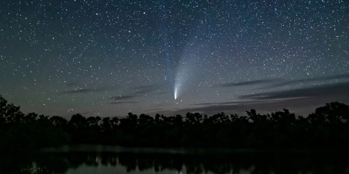
Silence the noise, escape the hurry, and feel light years away in the dark skies of Central Montana – where…
Read More
July 7, 2023
If you’re looking for a place to expand your horizons, literally and figuratively, then Central Montana needs to be at…
Read More
November 24, 2023
It’s wintertime and the holiday season is in full swing in Central Montana! If you’re in the region visiting friends…
Read More