Cascade

Tower Rock is located on the west side of the Missouri River, approximately eight miles south of Cascade, exit 247 off I-15. This was the end of the Great Plains and transition to the unknown Rocky Mountain terrain.
Chester
Eighteen miles south of Chester on Montana Secondary Road 66, are four interpretive signs detailing Meriwether Lewis’ 1805 and 1806 trips through this area.
Dupuyer/Valier

The Two Medicine Fight Site historic marker is near the junction of US Highway 89 and MT Highway 44. This marks the only hostile encounter with Indians experienced by the Corps of Discovery on their long journey.
On July 26, 1806, Captain Lewis and members of the Expedition left Camp Disappointment and traveled down the Marias River. There they encountered eight members of a Blackfeet tribe known as the Piegans.
Lewis explained that he had mediated peace between warring Indian nations on either side of the mountains. This was upsetting news to the Blackfeet Indians. Lewis informed them that not only did he organize the worst enemies of the Blackfeet-the Nez Perce, the Shoshones and others—he intended to supply them with weapons. Lewis and his men, unaware of the Piegans fear of their plans, settled down to sleep.
The next morning Lewis awoke to the shouts of his men. The Piegans were stealing their weapons. The men quickly chased the Indians and recovered their guns, but in the struggle one of the Piegans were stabbed and killed. This struggle also ended in the death of a Piegan at the hands of Lewis, who was almost shot.
This struggle on July 27, 1806, was the only violent conflict between the Corps of Discovery and American Indians and resulted in the only two Indian casualties of the Expedition. Furthermore, it marks the first meeting and conflict between any representative of the American government and the Blackfeet Indians.
Fort Benton

This historic town boasts Montana's Lewis and Clark Memorial; a heroic-sized statue of the explorers, Sacagawea and her son.
There is also a Bureau of Land Management visitor center featuring Lewis and Clark information as well as a video. The walking tour includes the steamboat levee, two museums, the ruins of the old fort and many other historical buildings. It is also a launch point for the 149-mile "Wild and Scenic Missouri River" waterway segment of the Lewis and Clark National Historic Trail and the western gateway for the Upper Missouri River Breaks National Monument.
Great Falls

Located on the Missouri River near a series of five waterfalls, Great Falls is the largest city in northcentral Montana. In 1805, the Lewis and Clark Expedition spent nearly a month portaging the falls. Several of the waterfalls may be viewed via the paved, non-motorized River's Edge Trail. It offers a unique experience to walk, jog, rollerblade or bike along the river.
Relive the Corps of Discovery's epic journey at the Lewis and Clark National Historic Trail Interpretive Center along the River's Edge Trail, an essential stop for visitors here.
Along the same stretch of the River's Edge Trail, Giant Springs Heritage State Park can be reached, as well as overlooks for Black Eagle and Rainbow Falls. Don't forget to visit Broadwater Overlook Park where the Visitors Center is located.
Designated Lewis and Clark sites in the Great Falls area include four camp sites, five waterfalls, Giant Springs, the location where Lewis was chased into the river by a grizzly, Sulphur Springs and the portage route used by the expedition. Additional sites, primarily camp sites, are located both upstream and further downstream. It was near Great Falls that Lewis identified the cutthroat trout (Montana's state fish), the western meadowlark (Montana's state bird), and the broadleaf cottonwood. All were new to science.
Lewistown

North of Lewistown and Winifred, the Judith Landing public access site provides an excellent opportunity to retrace a section of the actual Lewis and Clark Expedition trail on the Missouri River.
Loma

In June 1805, the Lewis and Clark Expedition spent nine days at the Marias River, trying to determine whether or not the Marias was a main stem of the Missouri; they correctly concluded that it was not. The instructions they had gotten from the Mandan tribe in North Dakota made no mention of the river. The waterway was especially confusing because of its size. Its wide, powerful nature in high water made it seem as likely a main river as the Missouri arm.
Lewis climbed to what is now called Decision Point Overlook for a better view of the surrounding land, in hopes of finding the right route. Lewis finally reasoned that the thick, dark waters of the Marias traveled too much to the north to be the Missouri. He felt that the clearer waters of the westward river must move through the high mountains. In the end, it was exploration that decided the matter, and Lewis was proved right.
Decision Point Overlook is located 11 miles north of Fort Benton on US 87. At the confluence of the Missouri River. The BLM has interpretive signs at Decision Point on the ridge above the Missouri.
First Peoples Buffalo Jump State Park
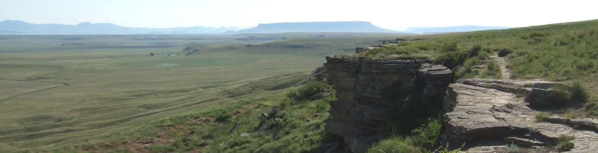
Visit First Peoples Buffalo Jump State Park to see what is believed to be one of the longest buffalo kill sites in the United States. Though not actually part of the Lewis and Clark route, Lewis described in great detail these buffalo kills, and First Peoples Buffalo Jump State Park gives visitors a way to "see" what Lewis described in his journal.
Native peoples used this site for at least two thousand years prior to Lewis and Clark's expedition through Montana. The kill site consists of a mile long sandstone cliff; there are remnants of drive lines on top of the cliff and the remains of millions of processed bison below. The park has an interpretive trail, shelters, picnic tables, fireplaces, and a protected black tailed prairie dog town to help the visitor better understand the epic history of hunting on the high plains.
First Peoples Buffalo Jump State Park is located 10 miles south of Great Falls on I-15 at Ulm Exit, then 3.5 miles northwest on county road.
More Lewis & Clark Trip Ideas


